• Home
  • About
  • Listed Climbs
Menu

Jeff Hebert

  • Home
  • About
  • Listed Climbs

Corkscrew Route on Sloan Peak

July 28, 2019

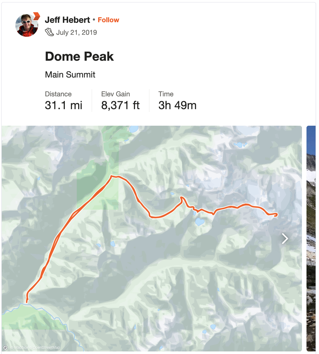
From Dome Peak last weekend, Sloan stood out on the horizon with its distinctive, matterhorn-esque shape. Erica and I were able to spare one day this weekend for an adventure and decided to brave an early wakeup in Seattle on Sunday to car-to-car the route. Most beta we could find suggested at least 11-12 hours, if not longer, so we got rolling by 4:30am from Seattle, made good time on the Mountain Loop Highway, and left the car at about 1,900 feet just after 6:30am. We opted for the Cougar Creek approach, hoping that the river crossings near the start would be relatively civilized at this time of year.

After working our way through the brushy trail from the car, we quickly hit the first river crossing. A bit of searching upstream found a great set of logs to cross. From there, we battled some brush and made a couple more crossings, finding faint trails at times, but generally using our topo and GPS to head in the right direction. After the last crossing, on a large, sandy, dry stream bed, we remembered the beta suggesting a departure from the old trail, heading upstream a ways before ducking into the forest.

From there, the trail was faint at first, but became more and more established. We went sharply uphill, switching back quite a bit until reaching an awesome waterfall where we crossed the creek and continued up. At 9am, after about 2.5 hours, including some brushy sections that were a bit hard to follow at times, we made it to open views at 5,000 feet. We’d been cruising to this point and made the wise decision to sit down and eat our snack of salami and cheddar before continuing up.

After following the trail up the ridge, we followed up on scree and slabs to the saddle at 5,800 feet, neglecting to read the beta suggesting that the summer route continues up the grassy ridge. In either case, it was a direct approach and went quickly, allowing us to make the saddle just before 10am. At the saddle we headed through and turned right, following more slabs up to a pretty high access point on the glacier. A party of four had just descended the glacier and were taking their crampons off as we arrived and put ours on. It sounded like everything was in good shape.

We headed up the glacier with our gear and light rope on, following a nice boot pack around some crevasses and eventually traversing to bare rock at the Southeast edge of the summit block at about 11:15am. We left our technical gear and poles here, then continued up on the classic climber’s path for the summit. There were a few fun sections requiring hands, but it always felt comfortable as 3rd/4th class. We made it to the top a few minutes before noon and took in the crystal-clear views over lunch.

Not much to say about the descent, save that we went down the snow as far as it would take us on the glacier and made one magical stop at the waterfall to dunk our feet. We were back at the car just after 4:15pm for about 9h 45m on the day, which gave us the time to drive home via Darrington and milkshakes.

In Climbing
Comment

Dome Peak from Itswoot Ridge

Dome Glacier on Dome Peak

July 20, 2019

Cub Lake and Glacier Peak

Dome Peak has been lurking on my list for a long time. I expected to get back there at some point on a Ptarmigan Traverse, but things lined up to head back there with Colin as a two-day weekend mission. We were both interested in going somewhere beautiful, fast and light.

We drove up on Friday night and spent the night at the Downey Creek Trailhead in the car. With a 5am wakeup, we were on the move by 6am Saturday morning. We made it to the 6.5-mile first turn in 2 hours, then cruised up the valley, cutting into an overgrown area at about 4,000 feet and crossing Bachelor Creek into a long section of brushy trail that felt like bushwhacking at times. This area collected dew and made us really wet, soaking our pants, socks, and shoes in particular.

Things improved from about 4,800 feet on and eventually entered a gorgeous area at Cub Lake, with views South to Glacier Peak, at about 11:45am. We climbed up Itswoot Ridge at 6,300 feet and got our first full view of Dome Peak at 1:15pm. The traverse from there went pretty quickly. We were able to stay on the left margin of some snow to gain elevation and didn’t put our crampons on until we were at 7,200 feet or so. We made it to the saddle at 4:30pm and dropped our overnight gear there.

After a quick break at camp, we headed up more untouched snow to the summit at 5:30pm. It was a great view from such a central location in the North Cascades. We took it in for a while, scouted out Sinister a bit, and decided that, without a rope, it didn’t make sense to drop down and try to do Sinister as well. So we headed down to camp, ate dinner, and got in bed well before sunset.

Looking at Eldorado, Forbidden, Sahale, Boston, Buckner, Logan, and Goode

Taking in the summit view

Descending from the top with Gunsight and Bonanza behind

While it was a nice and calm evening, the wind kicked up fiercely around midnight and made for some pretty challenging sleeping conditions. Colin got a hole in his pad (potentially from a snafflehound chomp), so he was in an especially tough spot. We decided to get up at 4:30am and start our trek back out. Everything went smoothly enough and we were back at the car by 2:30pm. The GPS suggested it was about 31 miles and 8,400 vertical on the weekend.

Leaving in the early morning

‘Schwacking Back Out

In Climbing
Comment

Descending as the clouds rolled in

West Spur on Illimani

June 12, 2019

Dale grabs a pickaxe and helps clear ice from the road as Illimani looms.

After Dale and I had experienced near-perfect weather, conditions, and logistics during our time in Bolivia, enabling us to climb Pequeño Alpamayo, Cabeza de Condor, Huayna Potosí, and Illampu in the span of two weeks, we debated what to do to cap off our trip. Initially, we considered an ambitious traverse of the Illimani massif, summiting the North, Central, and South peaks in a clockwise horseshoe—we were acclimatized, fit, and capable of the technical difficulties. Dale wasn’t feeling 100% following our Illampu adventure and we both had some trepidation regarding a long, cold day on high-consequence terrain all above 20,000 feet, so we decided to play it safe and do the normal route.

We phoned up our taxi driver, Manuel, from Huayna Potosi and arranged to be picked up at 8am on Tuesday. He gave us the options of Puente Roto and Pinaya, which was an easy decision since Puente Roto cut off about an hour and a half of the approach. It turned out this meant we took a completely different road, which was, in a word, rowdy. Manuel’s sedan miraculously made it after 3.5 hours of driving, including one point where Dale and I got out of the car to help clear ice off the road along with another carful of Bolivians headed to one of the tiny mountain villages along the way.

At 11:30am or so, we started hiking up the well-worn trail toward Nido de Condores (The Condor’s Nest). We took our time, knowing all we needed to do was reach camp, eat, and go to bed. The trail swept across the glacial valley and over a moraine before steeply heading up the West Spur. We made it to camp a bit after 4pm and spent some time buffing up a campsite as far off on our own as we could. A large cook’s tent and a few other individual tents were already set up in the relatively small camp area. We chatted up a Spanish group and the guides at camp before eating a dessert, having some tea, and taking a nap before dinner—one of my favorite approach day past times.

Dale, heading up the cold face

Most parties in Bolivia, especially guided ones, seem to get very early starts—typically somewhere between midnight and 2am. We didn’t see a need to do that for the normal route on Illimani and instead slept in, starting in earnest from camp at 6:30am. The route had a well-worn track and never got terribly steep. I felt comfortable with a pole and a whippet the whole way and we never roped up. The biggest danger came from a few crevasse crossings, but they were obvious and the snow bridges were solid. My only issue on the day was cold fingers and toes since we were on the West side of the peak at over 20,000 feet and didn’t see sun until near the summit ridge.

Coming up the summit ridge. Photo by Dale Apgar.

Dale on the summit

We topped out in about 4 hours, including a long walk along the low-angle summit ridge to get to the very top at 21,122 feet. After over 2 weeks at elevation and having climbed a bunch by that point, we both felt surprisingly good on top. We snacked for a bit before turning around and romping down the route in 2 hours, reaching camp at 12:30pm where we had another dessert, tea, nap trifecta. We were treated to an awesome light show that evening.

Looking out our tent

Walking down to Pinaya

Our hike out on Thursday was uneventful except for needing to hike an extra hour since the folks in Pinaya wouldn’t let our taxi up on their private road to collect us. Having to walk down the pampas with a cornucopia of farm animals and continued views of Illimani wasn’t so bad.

In the end, we were glad to have kept it low-key on this one and gotten to the top of Illimani. Now that we’ve gauged ourselves at over 21,000 feet, taking on something like the traverse seems very doable.

Great cap off to an awesome trip!

In Climbing
Comment
← Newer Posts Older Posts →

Recent Trip Reports

Featured
IMG_9162.jpg
May 31, 2025
Mallory-Porter on Aiguille du Midi
May 31, 2025
May 31, 2025
ventoux.jpg
May 18, 2025
Mont Ventoux
May 18, 2025
May 18, 2025
IMG_6830.jpeg
Sep 21, 2024
South Face on Aiguille du Moine
Sep 21, 2024
Sep 21, 2024
IMG_6771.jpeg
Sep 19, 2024
Barbaresco to Barolo
Sep 19, 2024
Sep 19, 2024
IMG_3321.jpeg
Sep 15, 2024
Cosmiques Arete on Aiguille du Midi
Sep 15, 2024
Sep 15, 2024
IMG_5955.jpeg
Jul 27, 2024
Rainier Vertfest
Jul 27, 2024
Jul 27, 2024
IMG_5609.jpeg
Jul 13, 2024
Mary Green Glacier on Bonanza Peak
Jul 13, 2024
Jul 13, 2024
IMG_4891.jpeg
Apr 13, 2024
Chair Peak Circumnav CCW
Apr 13, 2024
Apr 13, 2024
IMG_8600.jpeg
Dec 14, 2023
Mount Aspiring NW Ridge
Dec 14, 2023
Dec 14, 2023
IMG_2329.jpeg
Jul 16, 2023
West Ridge on Mount Thomson
Jul 16, 2023
Jul 16, 2023
IMG_1974.jpeg
May 28, 2023
South Ridge on Mount Jefferson
May 28, 2023
May 28, 2023
IMG_1736.jpeg
May 13, 2023
Little Tahoma via Paradise
May 13, 2023
May 13, 2023
IMG_3023.jpeg
Mar 18, 2023
Nisqually Chute on Mount Rainier
Mar 18, 2023
Mar 18, 2023
IMG_9312.jpeg
Feb 12, 2023
The Slot Couloir on Snoqualmie Mountain
Feb 12, 2023
Feb 12, 2023
IMG_0141.jpeg
Sep 25, 2022
The Triad
Sep 25, 2022
Sep 25, 2022
IMG_0024.jpeg
Sep 5, 2022
Mount Fernow
Sep 5, 2022
Sep 5, 2022
IMG_9826.jpeg
Aug 7, 2022
Frostbite Ridge on Glacier Peak
Aug 7, 2022
Aug 7, 2022
IMG_9661.jpeg
Jul 23, 2022
North Face of Mount Maude
Jul 23, 2022
Jul 23, 2022
IMG_9557.jpeg
Jul 9, 2022
Tahoma Glacier on Mount Rainier
Jul 9, 2022
Jul 9, 2022
IMG_9431.jpeg
Jun 25, 2022
Squak Glacier on Mount Baker
Jun 25, 2022
Jun 25, 2022
IMG_8289.jpeg
Mar 16, 2022
Bow-Yoho Traverse
Mar 16, 2022
Mar 16, 2022
IMG_7941.jpeg
Jan 29, 2022
Oyster Couloir on Wright Mountain
Jan 29, 2022
Jan 29, 2022
IMG_7717.jpeg
Oct 16, 2021
Mount Saint Helens Windy Ridge Ride
Oct 16, 2021
Oct 16, 2021
IMG_7676.jpeg
Oct 2, 2021
North Cascades Highway Ride - Newhalem to Mazama and Back
Oct 2, 2021
Oct 2, 2021
PXL_20210721_200419965.jpg
Jul 21, 2021
Twin Sisters Traverse
Jul 21, 2021
Jul 21, 2021
IMG_7050.jpg
Jul 18, 2021
Mount Challenger via Whatcom Pass
Jul 18, 2021
Jul 18, 2021
IMG_6821.jpg
Jun 26, 2021
Emmons Glacier on Rainier Car to Car
Jun 26, 2021
Jun 26, 2021
IMG_6572.jpg
May 30, 2021
Park Glacier on Mount Baker
May 30, 2021
May 30, 2021
IMG_6402.jpg
May 15, 2021
Mesachie Glacier
May 15, 2021
May 15, 2021
IMG_6185.jpg
May 2, 2021
Northwest Face on Cashmere Mountain
May 2, 2021
May 2, 2021

© 2020 Jeffrey J. Hebert