• Home
  • About
  • Listed Climbs
Menu

Jeff Hebert

  • Home
  • About
  • Listed Climbs

The final summit ridge. Photo by Dale Apgar.

French Route on Huayna Potosí

June 2, 2019

Dale and I decided it would be wise to climb Huana Potosí at 19,974 feet before attempting one of the even higher peaks in Bolivia during our trip. We’d worked up to it with about a week in the country and climbs of Pequeno Alpamayo and Cabeza de Condor, so we felt pretty good at elevation. We decided to go car-to-car rather than hiking overnight gear up to one of the high camps.

We weren’t sure how to find a taxi to head out there, so we tried Uber. Ha! A driver immediately accepted our ride for 100 Bolivianos and then looked very confused when we said where we were headed. We agreed to cancel the Uber ride and pay him cash for the much longer drive. He was a teacher, driving on the weekends as a side hustle, and a cool guy. His car was ill-equipped for the rocky road, but we made it and paid him 300 Bolivianos when we made it to the dam at Zongo Pass.

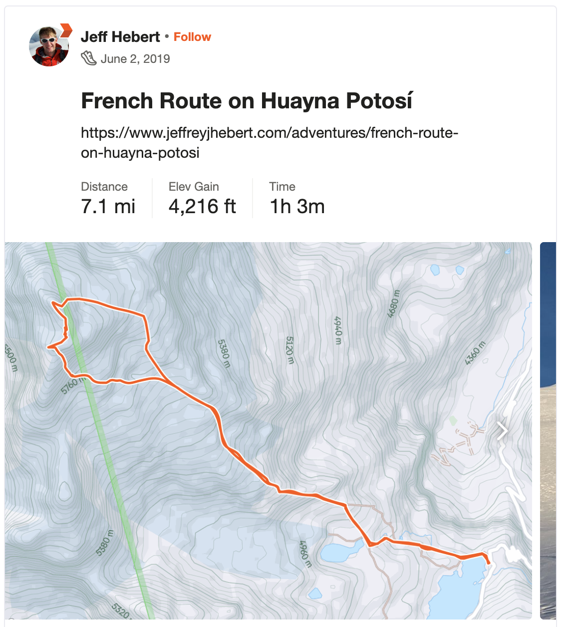
We set up our tent on the concrete platform next to the refugio at 15,500 feet and spent the evening watching the mist push up the valley from the Amazon in waves and staring longingly at the mountain. We woke up at 3am and were moving after a half hour of breaking down camp and putting down some calories. We walked across the dam, balanced our way across the narrow wall of a concrete sluice, and then headed up a rough path to meet the main trail.

Photo by Dale Apgar.

We made it to the rock camp at 17,000 feet in a little over an hour, passing the time on the trail with some idle banter and a couple of choice songs from our phones. At one section between the two refugios, we weren’t sure where the trail went and we ended up going straight up a steep rock face—whoops! It was very cold and still dark at the toe of the glacier where we dropped our trail runners and put on our big boots. A party of three were descending under headlamp—a client and two guides, apparently unsuccessful on the main route. We started huffing up the glacier and made it to the flatter area where Campamiento Argentino supposedly is located at about 6:30am. There were no signs of a camp, but there was a huge ice fall coming down the glacier right next to the normal route.

We departed the normal route at 7am and did a rising traverse for the next hour and a quarter to make it to the base of the route. We took a moment here to put down some water and calories, which made both of us feel quite a bit better. What had been a cold morning had turned into a solar cooker on the East Face. The snow had softened nicely and there was a boot pack up the face, so it went quickly. We high-daggered our faces off for about 1,000 feet, simul-soloing the slope that slowly increased in angle up to 55 degrees or so and reaching the top in an hour.

Taking a break in the saddle before the summit ridge. Photo by Dale Apgar.

From there, the ridge to the summit looked like a lot of fun and more enjoyable than dropping down through the saddle to meet the normal route, so we headed up the steep snow for some bonus climbing. Some of the ridge was a bit rotten and corniced, but not too bad. We made it through this section in 30 minutes and then scampered over to the true summit, minding the huge cornice, making it there just shy of 11am. Views were pretty spectacular up there and it was relatively warm and calm. We enjoyed the moment for a bit before starting down the highway that is the normal route.

The descent was straightforward and quick. We were back down at the base by 2:30pm, including a break for Dale to take some time lapse videos of the clouds. We unfortunately had to wait quite a while for a taxi at the refugio, which was pretty cold, but it was a good chance to nap and catch up on calories before scooting back to La Paz with a gregarious fellow of a taxi driver and a local guide who needed a ride as well.

Great day with constant movement and enough technical climbing to keep it interesting!

In Climbing
Comment

Photo by Dale Apgar

Southwest Ridge on Cabeza de Condor

May 30, 2019

After climbing Pequeño Alpamayo a day earlier than expected, our sights turned towards the Condoriri formation. It looms above camp at Laguna Chiar Khota as well as the entire drive into the area and the Cabeza de Condor is especially beautiful. During our rest day, Dale checked out the approach as we had only brought the beta for Pequeño Alpamayo and were both nervous about the glacier that appeared to be our only access to the upper plateau. Thankfully, Dale discovered the faint trail heading up from the moraine to the left of the glacier and explored all the way up to the plateau, so we knew we could access the climb.

Since our taxi pickup was scheduled for noon the next day, we used my satellite phone to ask Erica to reach our driver via whatsapp and push our pickup back to 4pm, which we figured would give us enough time to climb, descend, pack up camp, and get back to the trailhead. We woke up at 4:15am and were moving after a hot breakfast by 5am. We made it most of the way through the scree before the sun came up and bathed Huayna Potosi in alpenglow. From there, we went up and over the two small saddles to then drop down to the glacier. My breakfast wasn't sitting very well, likely due to the altitude, and I unfortunately let it go with some fury around daybreak. I tried to put down some food soon thereafter and my stomach wasn't having any of it, so I resolved myself to it being "that kind of day."

We reached the base of the Cabeza de Condor at 9am and found the couloir to the climber's right of the main ridge in great condition. After saying hello to a party of 2 guides on their way down, we soloed up to the end of the couloir and then put on the rope for the last 15m, which were really fun alpine ice where the couloir necked down enough to allow chimney moves. From there, we coiled a bunch of the rope and set off on the summit knife-edged ridge. It was quite exposed and steep on both sides, but never too tough and there was a good boot pack in it, so we moved quickly. The ridge undulated from low-enough angle to walk upright to steep and needing to high-dagger both tools. It was great fun and really gorgeous, with views of Huayna Potosi to the South and Illampu and Ancohuma to the North. We passed a party of 2 from Canada on the ridge who were pitching out the climb on our way.

We reached the top at 10:15am. What a spot, with the mountain falling away sharply in all directions and views like you dream about. We hung out for a bit, crossed back past the Canadians, and down-climbed the ridge. We did a short rappel with our 30m glacier rope, which was a perfect length to get past the ice, before plunge-stepping down the couloir. It had been baking in the morning sun and was pretty wet and sloppy by that point at 11:30am, but not worrisome. Our saunter down the glacier and back to camp went without incident and gave me enough time to take a half-hour nap in the sun-baked tent to feel a bit better. We hiked out starting a little after 3pm and made it to the taxi at 4 on the nose. Our driver, Don Victor, was happy to see us and took our sleepy selves back to our apartment in La Paz where we went to town on Argentinian food.

It's always gratifying to accomplish something (in this case a climb) that, at first, one isn't sure is possible. Between the lack of beta, concerns about the approach, and timing, it seemed improbable to do this climb, but it worked out swimmingly.

Photo by Dale Apgar

In Climbing
Comment

West-Southwest Ridge on Pequeño Alpamayo

May 28, 2019

Heading up the steepest part of the glacier

For our first climb in Bolivia, Dale and I agreed Pequeño Alpamayo in the Condoriri Group would be a good objective. After 2 days and 3 nights in La Paz, we took a taxi at 9am up to Laguna Tuni. It took a little over 2 hours to get there and it turned out the road went a bit farther than I'd expected in my planning, so it only took an hour to reach Laguna Chiar Khota where we dropped our camping gear and set up our tent.

We'd planned to approach the first day, climb the second, and descend the third, but we both felt great at our camp at 15,300 feet and decided the route would not be dangerous in the afternoon, so we went for it starting at 1:15pm.

We quickly hiked up the valley, put our boots, crampons, and harnesses on at the toe of the glacier, and started walking up the snow at 2:15pm The crevasses were obvious, so we didn't rope up. There was a well-worn track in the snow that switched back up the glacier to the saddle. From there, we followed the tracks up and right to the top of the sub peak where we got our first full view of the route. It was magical. Mornings in Bolivia had been clear while afternoons were cloudy and we had been worried the summit would be socked in, but it turned out to be clear with wispy clouds adding to the ambiance.

We descended on 4th class rock to the saddle below the peak and then soloed our way up the 45-50 degree snow with perfect sticks. The route has a great, exposed feeling to it with the face dropping off to the right, but the climbing being at a very reasonable angle. One exposed step past some rock near the top brought us to the final slope and then the summit at 5pm. What a beautiful spot!

We down-climbed the ridge, scrambled back up the 4th class, and then sauntered down the glacier, which was soft enough to take plunge steps pretty well. We were back at our trail runners a little after 6pm and hiked to our tent as the dark crept in by 7pm. Perfect first climb in the mountains here!

In Climbing
Comment
← Newer Posts Older Posts →

Recent Trip Reports

Featured
IMG_9162.jpg
May 31, 2025
Mallory-Porter on Aiguille du Midi
May 31, 2025
May 31, 2025
ventoux.jpg
May 18, 2025
Mont Ventoux
May 18, 2025
May 18, 2025
IMG_6830.jpeg
Sep 21, 2024
South Face on Aiguille du Moine
Sep 21, 2024
Sep 21, 2024
IMG_6771.jpeg
Sep 19, 2024
Barbaresco to Barolo
Sep 19, 2024
Sep 19, 2024
IMG_3321.jpeg
Sep 15, 2024
Cosmiques Arete on Aiguille du Midi
Sep 15, 2024
Sep 15, 2024
IMG_5955.jpeg
Jul 27, 2024
Rainier Vertfest
Jul 27, 2024
Jul 27, 2024
IMG_5609.jpeg
Jul 13, 2024
Mary Green Glacier on Bonanza Peak
Jul 13, 2024
Jul 13, 2024
IMG_4891.jpeg
Apr 13, 2024
Chair Peak Circumnav CCW
Apr 13, 2024
Apr 13, 2024
IMG_8600.jpeg
Dec 14, 2023
Mount Aspiring NW Ridge
Dec 14, 2023
Dec 14, 2023
IMG_2329.jpeg
Jul 16, 2023
West Ridge on Mount Thomson
Jul 16, 2023
Jul 16, 2023
IMG_1974.jpeg
May 28, 2023
South Ridge on Mount Jefferson
May 28, 2023
May 28, 2023
IMG_1736.jpeg
May 13, 2023
Little Tahoma via Paradise
May 13, 2023
May 13, 2023
IMG_3023.jpeg
Mar 18, 2023
Nisqually Chute on Mount Rainier
Mar 18, 2023
Mar 18, 2023
IMG_9312.jpeg
Feb 12, 2023
The Slot Couloir on Snoqualmie Mountain
Feb 12, 2023
Feb 12, 2023
IMG_0141.jpeg
Sep 25, 2022
The Triad
Sep 25, 2022
Sep 25, 2022
IMG_0024.jpeg
Sep 5, 2022
Mount Fernow
Sep 5, 2022
Sep 5, 2022
IMG_9826.jpeg
Aug 7, 2022
Frostbite Ridge on Glacier Peak
Aug 7, 2022
Aug 7, 2022
IMG_9661.jpeg
Jul 23, 2022
North Face of Mount Maude
Jul 23, 2022
Jul 23, 2022
IMG_9557.jpeg
Jul 9, 2022
Tahoma Glacier on Mount Rainier
Jul 9, 2022
Jul 9, 2022
IMG_9431.jpeg
Jun 25, 2022
Squak Glacier on Mount Baker
Jun 25, 2022
Jun 25, 2022
IMG_8289.jpeg
Mar 16, 2022
Bow-Yoho Traverse
Mar 16, 2022
Mar 16, 2022
IMG_7941.jpeg
Jan 29, 2022
Oyster Couloir on Wright Mountain
Jan 29, 2022
Jan 29, 2022
IMG_7717.jpeg
Oct 16, 2021
Mount Saint Helens Windy Ridge Ride
Oct 16, 2021
Oct 16, 2021
IMG_7676.jpeg
Oct 2, 2021
North Cascades Highway Ride - Newhalem to Mazama and Back
Oct 2, 2021
Oct 2, 2021
PXL_20210721_200419965.jpg
Jul 21, 2021
Twin Sisters Traverse
Jul 21, 2021
Jul 21, 2021
IMG_7050.jpg
Jul 18, 2021
Mount Challenger via Whatcom Pass
Jul 18, 2021
Jul 18, 2021
IMG_6821.jpg
Jun 26, 2021
Emmons Glacier on Rainier Car to Car
Jun 26, 2021
Jun 26, 2021
IMG_6572.jpg
May 30, 2021
Park Glacier on Mount Baker
May 30, 2021
May 30, 2021
IMG_6402.jpg
May 15, 2021
Mesachie Glacier
May 15, 2021
May 15, 2021
IMG_6185.jpg
May 2, 2021
Northwest Face on Cashmere Mountain
May 2, 2021
May 2, 2021

© 2020 Jeffrey J. Hebert